1. Independent Trekking of Lao Than and Things to Know Before Starting
1.1. Where is Mount Lao Than?
Mount Lao Than belongs to Phin Ho commune, located in the Y Ty area, Bat Xat, Lao Cai, about 70-100km from Sa Pa depending on the travel route. With a height of 2,865 m above sea level, the mountain is likened to the “roof of Y Ty” and is one of Vietnam's prominent high mountain peaks.
The characteristic feature of Lao Than is its long, gentle grassy slopes, with few steep cliffs like many other trekking routes. The ecosystem here is rich with grass intertwined with low-lying fields and dense green forests, creating a vibrant natural landscape – especially ideal for photography enthusiasts.
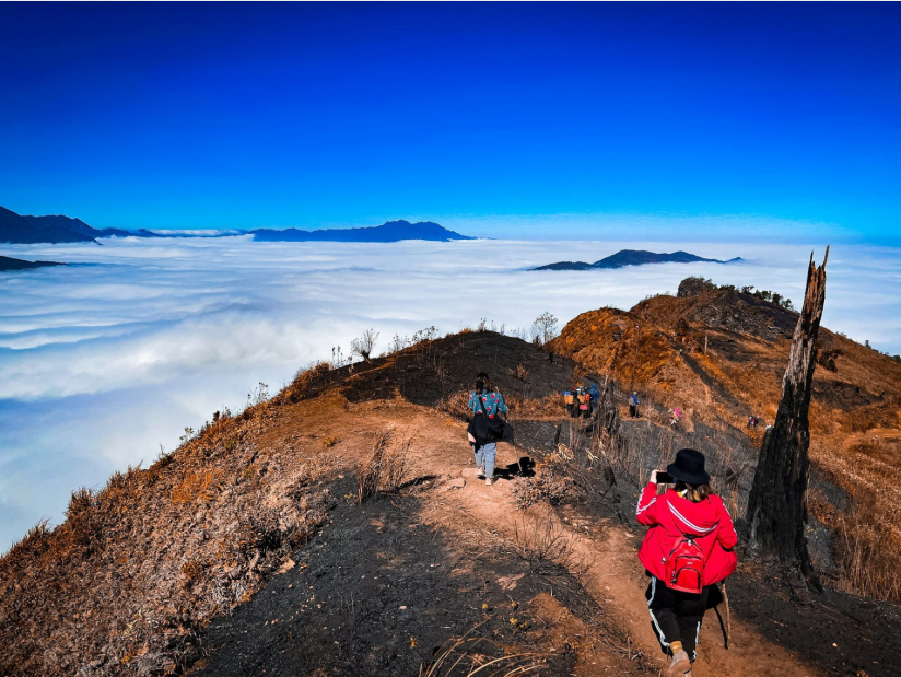
One of the factors that makes Lao Than a favorite trekking destination is its thick sea of clouds and 360-degree panoramic views. In the early morning, the scene of the sun gradually rising amidst the white clouds creates a very impressive landscape. On the journey to conquer the peak, visitors can stop at many scenic spots such as sunset-viewing rock outcrops, the lone tree near A Ho's hut, or the grassy slopes halfway up the mountain where one can gaze at the terraced fields and the vast Y Ty sea of clouds.
1.2. Outstanding Features Attracting Tourists to Trek Lao Than
Trekking Lao Than attracts tourists not only for its impressive height but also because it possesses a series of unique highlights, creating an emotionally rich conquering journey:
14th highest peak in Vietnam - Height: 2860m.
“Specialty” sea of clouds - one of the most beautiful cloud-hunting spots in Vietnam.
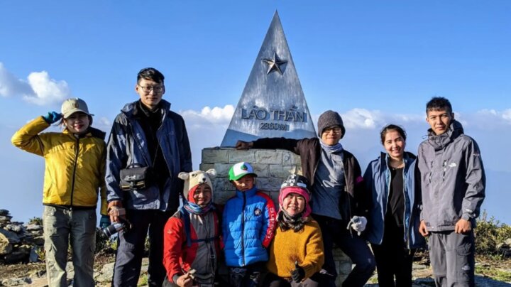
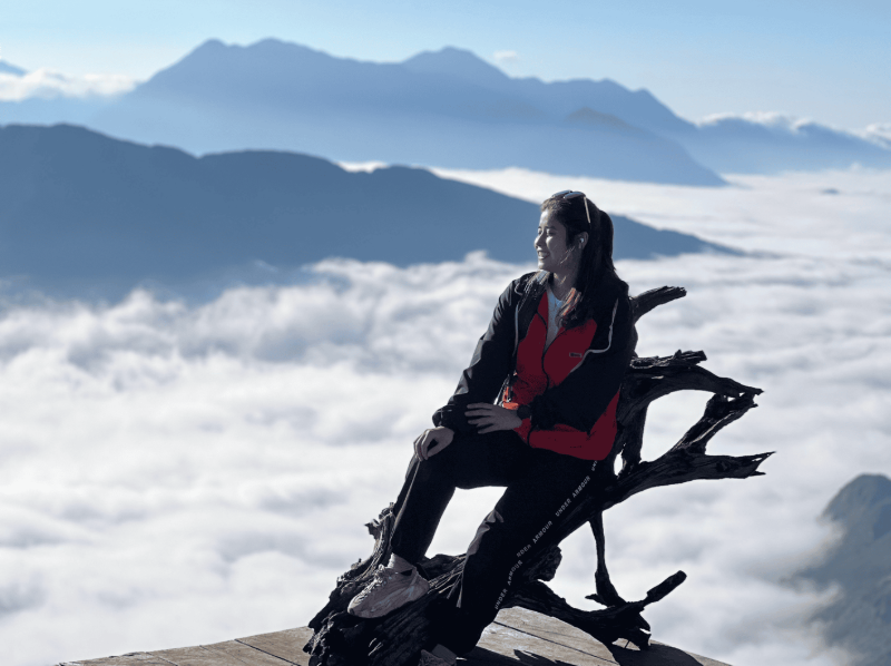
Dong Doi Peak: the legendary group photo spot.
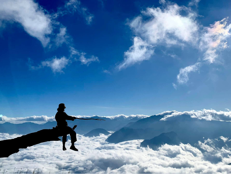
Tien Ong Fishing Peak (also known as Devil's Tongue Peak): famous for photos of people sitting precariously amidst the sea of clouds.
Many magical photo opportunities throughout the trekking journey.
1.3. Who is Independent Trekking Lao Than Suitable For?
Independent trekking of Lao Than is a moderately difficult journey, often jokingly called a "rejuvenation" trek. Most of the path goes through gentle grassy slopes with mild inclines, requiring almost no rock climbing, making it very suitable for those new to trekking.
This is an ideal choice for first-timers attempting heights over 2,800 m but who do not want to face overly challenging terrain. The route is also suitable for groups of young people who enjoy independent exploration, backpackers, and those who love cloud hunting and photography.
Lao Than has long been noted by many photographers and travel bloggers as one of the beautiful cloud-hunting spots in Y Ty. (Source: Collected)
Many people choose to trek Lao Than independently because they can have complete control over their time and itinerary. You can easily decide the departure time, rest time, or camping location that suits your cloud-hunting goals and weather conditions.
Thanks to this flexibility, the experience becomes more complete: you can visit villages, admire terraced fields, stop at mountain passes to interact with locals, and capture memorable moments at your own pace.
2. How to travel when trekking Lao Than independently
For visitors departing from Ho Chi Minh City, you will need an additional flight or bus trip to Hanoi before starting the journey to explore Lao Than. Each mode of transport has its own advantages: airplanes save time, while sleeper buses are suitable for budget-conscious travelers. To reach the starting point of the Lao Than trekking route, the journey is usually divided as follows:
2.1. First leg: Hanoi → Sa Pa → Y Ty (Lao Cai)
From Hanoi to Sa Pa center:
You start from Hanoi center heading towards Nhat Tan Bridge, drive straight along Vo Nguyen Giap street to merge onto the Noi Bai - Lao Cai expressway. This is a modern, easy-to-navigate, and time-saving route.
When you reach the intersection with National Highway 4D, turn left and continue through Dien Bien Phu street, following the foot of Ngu Chi Son mountain to enter Sa Pa center. (This route is the most popular suggestion for tourists because it is easy to drive and the scenery along the way is beautiful.)
From Sa Pa center to Y Ty:
From Sa Pa center, continue on National Highway 4D, then turn onto Road 155.
At the intersection of Road 155 and 158, turn onto Road 158 - the road leading directly to Y Ty commune, where the journey to conquer Lao Than peak begins.
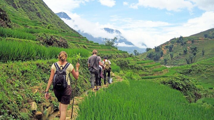
This route is not too complicated, but the scenery on both sides is very characteristic of the Northwest mountains and forests: terraced fields, drifting clouds, and small villages nestled in the valleys.
Important note: The road from Sa Pa to Y Ty has many narrow and steep bends, especially during the rainy season when it can be slippery. Therefore, if you are not confident in your driving skills or want to ensure maximum safety, you should consider taking a bus from Sa Pa to Y Ty or taking a train from Hanoi to Lao Cai and then hiring a service car in Sa Pa center.
2.2. Second leg: From Y Ty commune → Base of Lao Than mountain
The road from Y Ty center to the base of the mountain - the starting point of the trek, is not too far but requires concentration. The Lao Than route is still quite new, and the terrain changes constantly, so visitors can easily take a wrong turn if they are not familiar with the area.
For this reason, hiring a local porter is a worthwhile option. They not only guide you accurately but also assist you throughout the journey, which is especially helpful for those trekking in Y Ty for the first time.
Some tourists hire porters familiar with the terrain of Lao Than mountain for a more convenient trip. (Source: Collected)
The distance from Y Ty to the foot of Lao Than mountain is about 10 km, with many steep sections and uneven road surfaces, occasionally appearing with gravel or mud during the rainy season. If traveling by motorbike, you should hold the handlebars firmly, reduce speed when cornering, and avoid driving fast on steep slopes.
Despite the somewhat challenging road, the scenery on both sides offers a worthwhile experience for tourists: terraced fields winding along the mountainside, traditional houses nestled in the clouds, and occasionally the sight of ethnic people leisurely going to their fields, all creating a very unique characteristic of Y Ty.
A small note: When parking your vehicle at the clean vegetable farm - the most popular parking spot for the Lao Than route, you should discuss and agree on the fee in advance. This helps avoid unexpected expenses and ensures peace of mind throughout your trip.
2.3. The third leg: Starting the Lao Than trekking journey
After arriving at the foot of Lao Than mountain, your actual trekking journey officially begins. The path leading to the 2,860m peak opens up before you, not only a test of physical strength but also a true nature experience. Each step brings you closer to Y Ty's "cloud paradise," where just by looking up, you can feel the clear air and the very characteristic tranquility of the wild mountainous region.
The higher you go, the more the scenery changes. Golden grass carpets stretch along the mountainside, dense green forests interweave, and thin mist drifts slowly through narrow paths. Many tourists often say they feel "small" before nature, but excited as they get closer to the sea of clouds.
Upon reaching the "foot of the clouds" area - the point where layers of clouds begin to drift lazily below your feet, an overwhelming feeling is understandable. White clouds roll up from the valley, and sunlight pierces through the mist, creating incredibly beautiful light patterns. This is precisely the moment that makes Lao Than one of the most beloved cloud-hunting spots in Y Ty.
3. Detailed 2-day 1-night self-guided Lao Than trekking itinerary
The 2-day 1-night itinerary is scientifically arranged for you to have enough time to reach the summit, enjoy the beauty of the sea of clouds, and witness the sunrise at Lao Than. It is suitable for the physical fitness of most novice trekkers.
3.1. Day 1: Preparation - trek through grass hills - overnight near the summit
In the morning, have breakfast in Sa Pa or Y Ty, and double-check personal items such as backpacks, food, water, raincoats, flashlights, and trekking poles. Around 7-8 AM, the group will travel by motorbike or 16-seater car to the vegetable farm at the foot of Lao Than mountain. Here, vehicles will be parked, shared equipment will be received from the porters, and a light warm-up will be done before starting the climb.
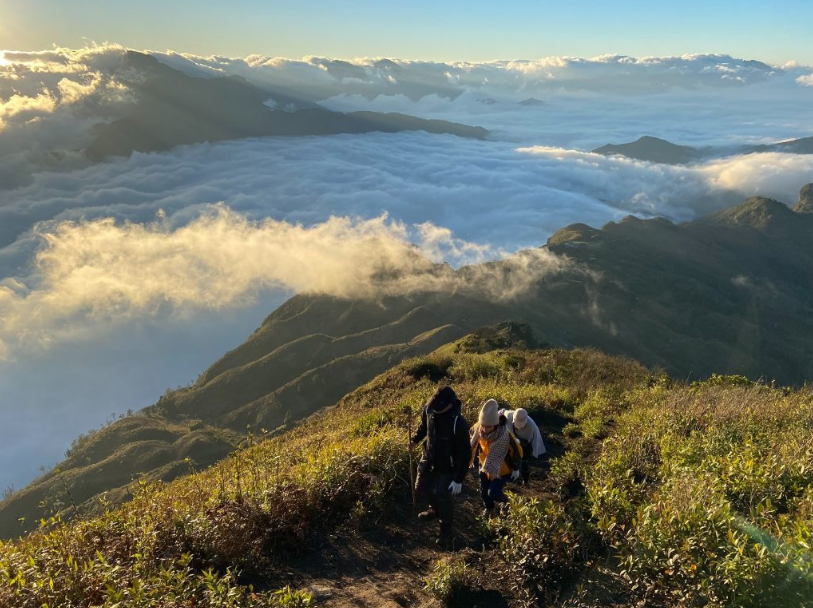
From 9:30-10:30 AM, the self-guided Lao Than trekking journey officially begins from the vegetable farm along the mountain trail. The terrain is quite easy at first with grassy areas, sparse forest fields, and wide trails. A packed lunch will be served around 12-1 PM at a flat spot with shade or a clearing; the menu usually consists of packed rice, sausages, fruits, and energy drinks prepared by you or quickly by the porters.
The self-guided trekking journey to Lao Than officially begins along the mountain trail. (Source: Collected)
In the afternoon, the group continued to cross grassy hills interspersed with gentle slopes and a few steeper sections. The scenery became increasingly expansive with leisurely clouds and vast mountains. Around 4-5 PM, the group arrived at the resting hut, about a 1-1.5 hour walk from the summit. If the weather is favorable, you can go to a rocky outcrop or a nearby grassy area to watch the sunset and take souvenir photos.
Dinner is when the whole group gathers to enjoy hot rice, stir-fried meat, wild vegetables, soup, and ginger tea. The time spent by the campfire, chatting and stargazing, is also a very special experience. When staying at the hut or in tents, remember to keep warm with thick clothing and sleeping bags as the temperature at high altitudes at night is often cold, especially when it's windy.
3.2. Day 2: Cloud hunting at Lao Than - Summiting - Return
The second day starts quite early, around 4-4:30 AM. Everyone wakes up, drinks warm water, puts on jackets, gloves, and hats, and prepares flashlights for the final ascent. From 4:30-5:00 AM, the group departs from the resting hut towards the summit in the light of flashlights. This section takes 1-2 hours depending on physical fitness, mainly consisting of grassy slopes and trails with increasing steepness.
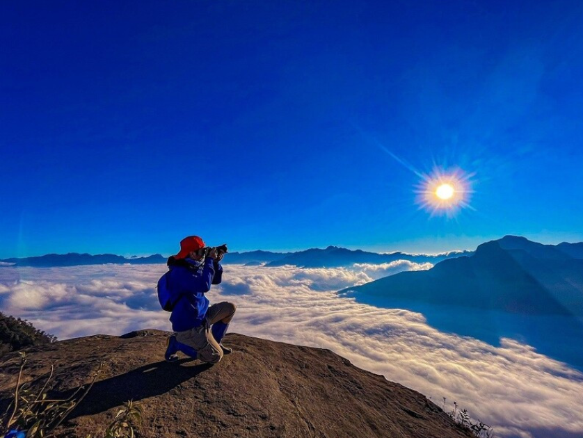
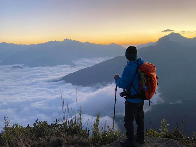
Visitors will witness the moment of sunrise over the sea of clouds. (Source: Collected)
When reaching the peak of Lao Than at 5:30-6:30 AM, you will witness the moment of sunrise over the sea of clouds from an altitude of 2,865m. The thick sea of clouds, with waves of clouds rolling over vast mountain ranges, creates a magnificent scene. This is the ideal time to take photos, record videos, and preserve the most memorable moments of the journey.
After sightseeing and taking photos, around 7-8:30 AM, the group returns to the shelter to have breakfast and pack up. You need to check and collect personal trash, ensuring no trace is left on the mountain. The descent begins from 8:30-9:00 AM via the old path; going down may be faster, but you should still be careful with each step to avoid slipping.
Around 12-1 PM, the group returns to the vegetable farm at the foot of the mountain, rests, and has lunch after an emotional trek. Afterwards, everyone retrieves their motorbikes and travels to Y Ty or Sa Pa to conclude the trip. Many groups will stop by Sa Pa for medicinal baths, dinner, and rest before returning to Hanoi the next day.
4. Updated Lao Than Trekking Costs
The cost for self-organized Lao Than trekking depends on the group's organization and service choices. Here is a reference price list to help you plan your trip finances:
Cost Item | Reference Price
|
Sleeper bus Hanoi - Sa Pa (round trip) | 400,000-600,000 VND/person |
Motorbike rental Sa Pa/Y Ty (1-2 days) | 150,000-200,000 VND/bike/day |
Fuel for travel | 100,000-150,000 VND |
Porter rental | 1,000,000 VND/2 porters |
Snacks and drinks | 200,000-300,000 VND/person |
Shelter/accommodation on the mountain | 100,000-150,000 VND/person/night |
Other miscellaneous expenses (parking at the mountain base, etc.) | 100,000-200,000 VND |
The estimated total cost per person is around 1,200,000 - 1,800,000 VND for a 3-day, 2-night journey (including travel from Hanoi). Compared to all-inclusive tours, self-organized Lao Than trekking allows you more flexibility in costs and easier selection of services that suit your personal conditions.
To reduce costs, you should travel in groups of 4-6 people to share porters and common expenses. Proactively preparing food and drinks from Sa Pa or Y Ty will help save on food costs on the mountain. Additionally, tourists should survey prices and negotiate clearly with service providers to achieve the most reasonable rates.
5. Lao Than Trekking Safety Tips
Safety is always the top priority in every trekking trip. Although Lao Than is considered a not-too-difficult route, thorough preparation will make the journey smoother and more complete.
5.1. Physical Preparation and Necessary Gear
About 1-2 weeks before departure, you should spend time training your physical fitness by brisk walking, light jogging, climbing stairs, or wearing a backpack with weights to get used to carrying loads. During the climb, maintain a steady pace, step evenly, and breathe deeply and slowly, especially on steep sections. Drink water in small sips to avoid exhaustion and help your body adapt better.
Regarding gear, a trekking backpack with hip and chest straps and water resistance (or a backpack rain cover) will help you move comfortably. Trekking shoes with good grip are also essential; remember to try them on a few days in advance to avoid foot pain.
Trekking shoes with good grip are a must-have item. (Source: Collection)
You should also prepare a set of quick-drying clothes, a waterproof windbreaker, a woolen hat, gloves, and thick socks to stay warm during overnight stays. Additionally, a flashlight or headlamp is very useful for early climbs to catch the sunrise. Personal food should be light and compact, such as energy bars, chocolate, cashews, cookies, and drinking water.
5.2. Hiring a porter and navigation skills
Due to the terrain having many small forks and the weather often changing quickly, hiring a local porter is a reasonable choice. Porters not only guide you accurately but also know the best spots for sightseeing, cloud hunting, and capturing sunset/sunrise photos. They also assist with carrying shared items, preparing meals, and promptly handling unexpected situations along the way.
To ensure safety, you should travel in a group and always stay within the sight of your porter or group leader. When it's foggy or raining, slow down and stay closer to the formation. Checking the weather forecast before the trip is also crucial for choosing clear days, which offer the highest chance of cloud hunting.
You should also prepare a thin raincoat, waterproof bags for your phone and camera. A small first-aid kit including band-aids, medicated oil, stomach medicine, and heat patches will be extremely useful when needed. If you feel tired, dizzy, or short of breath, stop immediately to rest and inform your porter for timely assistance.
5.3. Absolute safety principles
When **trekking Lao Than** independently, you should not go alone; a group of 3–5 people accompanied by a guide porter is the safest and most reasonable choice. Before departing, clearly inform your relatives or friends about your itinerary and estimated return time so they can contact and assist if necessary.
Throughout the journey, safety is the top priority. If the weather shows signs of being unfavorable, such as heavy rain, strong winds, or thick fog, proactively stop or consider postponing the ascent to the summit. When descending, walk slowly, maintain a firm grip on the path, and be especially careful on sections with wet grass or dew that make the ground slippery.
Porters help tourists take a more convenient path and know the beautiful spots for sightseeing. (Source: Collected)
Before leaving Y Ty or Sa Pa after your journey, don't forget to recheck the brakes, lights, and other important parts to ensure the vehicle operates stably on steep mountain roads. Thorough preparation will give you more peace of mind and conclude the trip perfectly.
6. Suggested combined experiences: Trekking Lao Than, exploring Y Ty and Sa Pa
To make the journey richer, many tourists choose to combine self-guided trekking Lao Than with exploring attractive destinations around like Y Ty and Sa Pa. This arrangement saves time and offers diverse experiences.
Before or after trekking, you can visit the villages of the Ha Nhi and H'Mong people in Y Ty to discover their unique stilt houses and admire the vast terraced fields. The scenery of Y Ty with its characteristic misty fog and fresh air will help you feel relaxed.
Highland cuisine and homestay experiences amidst the villages will bring you unforgettable highland cultural experiences. On clear mornings, the sea of clouds in Y Ty is as beautiful as the scenery on the summit of Lao Than.
After completing the trek, many groups return to Sa Pa to relax with the Dao Red people's medicinal bath service, which helps relax muscles after hours of climbing. In the evening, strolling through Sa Pa night market, enjoying grilled food, and sipping coffee amidst the mountainous landscape is an ideal way to end a day full of experiences.
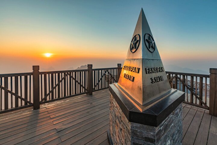
If you have more time, you can visit Sun World Fansipan Legend to make your trip more complete. Many activities attract a large number of tourists, with the Fansipan cable car offering an experience of admiring Hoang Lien Son from above and conquering Fansipan peak - the roof of Indochina. The complex also has many cultural and spiritual works, flower gardens, and beautiful squares for you to capture memorable photos.
Self-guided trekking Lao Than offers moments of immersion in the sea of clouds, a moderate challenge, and a sense of freedom when planning your own exploration. The journey to conquer Y Ty's roof, 2,865m high, is suitable for many people, from beginners to experienced trekkers. Plan your trip to experience one of the most beautiful cloud-hunting routes in Vietnam!