1. Where is Lung Po Flag Tower?
1.1. Overview of Lung Po Flag Tower
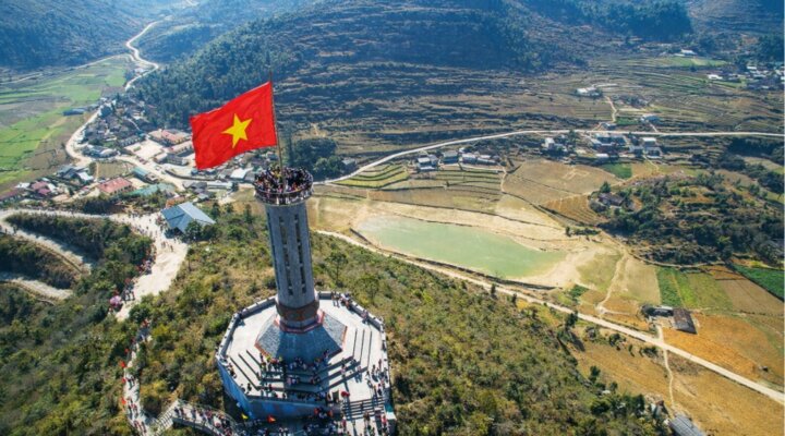
Lung Po Flag Tower is located in Lung Po 1 village, A Mu Sung, Bat Xat, Lao Cai, about 70 km northwest of the city center (now Lao Cai Ward). The structure is located right in the area of A Mu Sung Border Guard Station, on the Vietnam - China border line.
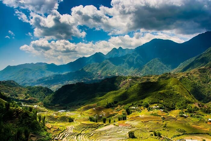
In the local dialect, Lung Po is also called Long Po, meaning "Father Dragon". This is a particularly important location as it is both the site of border marker number 92 and the confluence of the Red River and Lung Po stream. The two streams meet, creating natural green and pink hues, which vividly depict the landscape of the northern region of the Fatherland.
1.2. Special Significance of Lung Po Flag Tower
Lung Po Flag Tower is located at the point where the Red River first flows into Vietnamese territory after originating from Yunnan Province, China.
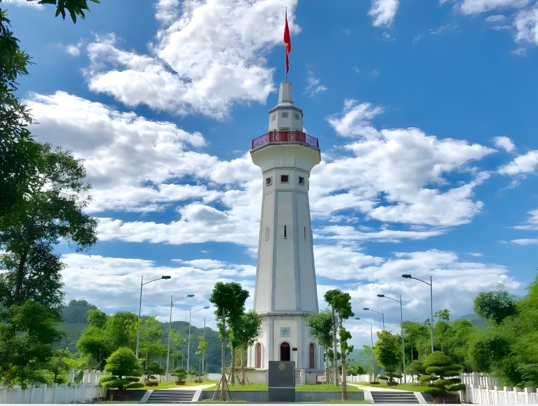
Lung Po Flag Tower is also a structure rich in historical and humanistic significance. (Source: Collected)
Lung Po Flag Tower was built to affirm the sacred sovereignty marker in the northern frontier of the Fatherland. The tower body is 31.43 m high, symbolizing the height of 3,143 m of Fansipan peak – the highest mountain in Vietnam. The national flag has an area of 25 m², representing the 25 brotherly ethnic groups living in Lao Cai province. To reach the top of the flag tower, visitors must conquer 125 spiral steps, creating a journey of experience and contemplation about the border space.
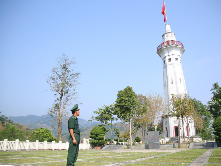
Not only possessing geographical and symbolic value, Lung Po Flag Tower is also a structure rich in historical and humanistic significance. Within the flag tower grounds, there is a space to worship President Ho Chi Minh and the border guards who bravely sacrificed their lives in the 1979 border defense war. This is a destination where flag-raising ceremonies, homeland activities, and traditional education for the young generation are regularly held.
2. Traveling to Lung Po Flag Tower
To reach Lung Po Flag Tower, most tourists choose to depart from Hanoi. The travel distance is over 360 km, with an average travel time of about 6–7 hours, depending on the means of transport and traffic conditions. Currently, thanks to the Noi Bai – Lao Cai expressway, the journey is much more convenient and shorter than before.
From Hanoi, visitors follow the Noi Bai – Lao Cai expressway to Lao Cai city (now part of Lao Cai ward). Besides personal cars or coaches, you can also choose to take a train to Lao Cai station, then rent a motorbike or car to travel to Bat Xat.
From here, the journey to Lung Po Flag Tower continues along provincial road DT156, then turns to DT158 and follows the road along the border area. The total distance from the city (Lao Cai ward) to the flag tower is about 80 km, with an average travel time of about 2.5 hours. As you go deeper into Bat Xat district, the terrain gradually turns into mountain pass roads with many curves and steeper slopes.
The road from A Mu Sung commune leading to Lung Po Flag Tower is somewhat winding and rougher, requiring drivers to concentrate and adhere to traffic safety. Motorbikes are suitable for tourists who love adventure and want to stop freely to take photos, explore villages, and admire the mountain scenery along the way. For families or large groups, a personal car or a pre-booked car service is a safer and more convenient option.
The weather in the Northwest region changes quite rapidly, especially during the rainy season. The suitable time to travel to Lung Po Flag Tower is usually during the dry season, when the weather is stable, with little rain, making it convenient for travel and sightseeing. On rainy days or in thick fog, visitors should limit travel as mountain pass roads are slippery and visibility is limited.
3. History and Architecture of Lung Po Flag Tower
3.1. Construction Process of Lung Po Flag Tower.
The land of Lung Po is associated with many important historical milestones in the process of defending the northern border of the Fatherland. In 1886, French warships advancing along the Red River to attack Lao Cai encountered fierce resistance from the local ethnic people. In the Trinh Tuong area, the Thao family militia organized an ambush, eliminating the enemy and creating the Tay waterfall. Eight years later, in the Lung Po area, the militia continued to ambush and inflict heavy losses on a French army.
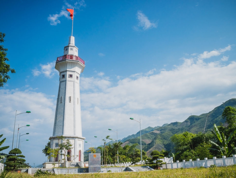
The land of Lung Po is associated with many important historical milestones in the process of protecting the northern border of the Fatherland. (Source: Collected)
To commemorate the victories and silent sacrifices at the border, the Standing Committee of the Lao Cai Provincial Youth Union proposed the construction of the youth project Lung Po Flag Tower – where the Red River flows into Vietnam, located at border marker number 92. The project is identified as having both the meaning of affirming territorial sovereignty and contributing to educating the tradition of "drinking water, remembering its source" for the young generation.
The Lung Po Flag Tower construction began on March 26, 2016, coinciding with the anniversary of the Ho Chi Minh Communist Youth Union's founding and serving as a project to celebrate the success of the 11th National Congress of the Ho Chi Minh Communist Youth Union. After more than a year of construction, the project was completed on December 16, 2017, and officially opened to visitors from early 2018.
The project was built and implemented in two phases:
Phase 1: focused on building the main flag tower, 31.43 m high, symbolizing the height of 3,143 m of Fansipan peak.
Phase 2: completed the external landscaping with items such as a lawn, parking lot, rubble masonry retaining walls, and surrounding fences.
The total construction cost for the Lung Po Flag Tower exceeded 17 billion VND, entirely mobilized from socialized funding, demonstrating the community's and youth's joint effort in preserving national border sovereignty.
3.2. Typical Architectural Features.
The Lung Po Flag Tower is designed with a height of 31.43 m, a symbolic number linked to the height of 3,143 m of Fansipan peak. This correspondence creates a meaningful connection between the "roof of Indochina" and the source of the Red River, clearly depicting the geographical space and sovereignty at the northern frontier of the Fatherland.
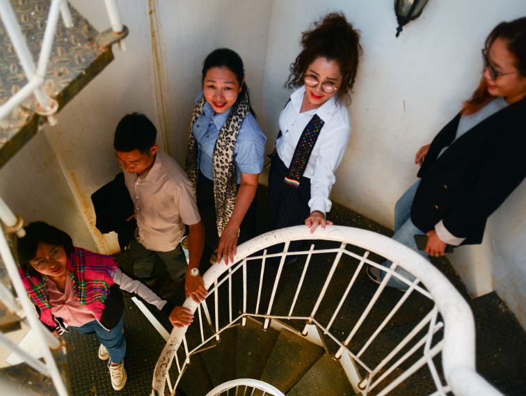
Inside Lung Po Flag Tower is scientifically designed with a system of 125 spiral steps. (Source: Collected)
The internal structure of the Lung Po Flag Tower is scientifically designed with a system of 125 spiral steps leading to the top. The journey of conquering each step is not only an experience but also gradually opens up the view for visitors as they ascend. From the top of the flag tower, the entire panorama of Bat Xat region unfolds, with the confluence of Lung Po stream and Red River at border marker number 92, interspersed with rolling mountains and villages nestled in the valley.
In terms of overall structure, the Lung Po Flag Tower is built with solid reinforced concrete, its octagonal shaft providing sturdiness, ensuring both technical soundness and aesthetic and symbolic value. The công trình stands out amidst the vast natural landscape, creating a distinct architectural highlight at the border. The surrounding grounds are harmoniously planned with lawns, stone embankments, fences, parking lots, and an administration building, catering to visitor needs, flag-raising ceremonies, and collective activities for traditional education.
3.3. A Symbol of Sovereignty on the Red River.
The Lung Po Flag Tower is located at the upstream source of the Red River, where the river begins to flow into Vietnamese territory, becoming a clear symbol of the message "where the Red River flows into Vietnam". The image of the national flag fluttering atop the tower, casting its reflection on the confluence of Lung Po stream and the Red River, not only carries geographical significance but also deeply engraves the sacred sovereignty of the northern border.
That space was once evoked in the familiar song "I am at the border where the Red River flows into Vietnam...", linking the image of soldiers on the front lines of the homeland with the flow of history and love for the country. Here, the Lung Po Flag Tower is not merely an architectural work, but also a spiritual symbol, a convergence of national pride and the sense of responsibility in preserving the national border.
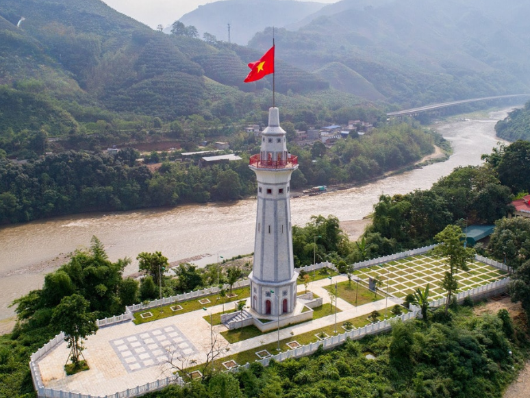
Image of the national flag flying high on the top of the pole, casting its shadow on the river. (Source: Collected)
The area of the flagpole and border marker No. 92 frequently hosts activities with political and social significance such as flag saluting ceremonies, traditional gatherings, and experiential programs for students and youth union members. In the moment of touching border marker 92, looking up at the red flag with a yellow star flying high atop Lung Po Flag Tower, then following the Red River as it begins its journey into Vietnam, feelings of national pride are awakened clearly and profoundly.
4. Suggestions for nearby tourist attractions to Lung Po Flag Tower
4.1. Lao Than Mountain - the "roof of Y Ty" amidst the sea of clouds in the Northwest
Lao Than Mountain is one of the highest peaks in the Y Ty region and is part of the Northwest mountain system. With an altitude of 2,862 m above sea level, Lao Than is known as the "roof of Y Ty" and is also one of the top trekking and cloud-hunting spots in the North.
The Lao Than trekking route is rated as moderately difficult, with terrain primarily consisting of gentle grassy hills and few steep cliffs, suitable even for novice trekkers with basic physical preparation. On the journey to conquer the summit, visitors have the opportunity to stop at many prominent scenic and photo-taking spots such as Mo Dong Doi or Mo Tien Ong Cau Ca, where impressive "sitting amidst the clouds" photos can be taken.

Visitors have the opportunity to stop at many outstanding scenic and photo spots. (Source: Collected)
Many tourists choose to combine their sightseeing trip to Lung Po Flag Tower with trekking Lao Than within a 2-3 day itinerary. Accordingly, the first day is for visiting the flag tower and border area, then moving to Y Ty; the next day starts trekking Lao Than early in the morning to catch the sunrise amidst a sea of clouds. This combination offers a complete experience, where majestic nature, local culture, and the imprint of border sovereignty blend together in an emotionally rich exploration journey.
4.2. Choan Then Park - a cultural space in the heart of Y Ty
Choan Then Park is only about a 3-minute drive from the center of the commune along the inter-village road. At the end of this road, visitors will encounter an open space of thousands of square meters – a place considered by locals as the center of cultural and spiritual life for the community.
Choan Then Park is a familiar gathering point for ethnic groups on holidays, Tet, New Year, or during the harvest prayer season. Here, people perform traditional religious rituals, chat, socialize, and participate in folk games that carry the distinct characteristics of the highlands. The community gathering atmosphere is natural and rustic, clearly reflecting the spiritual life of Y Ty residents.
Choan Then offers visitors a moment of quiet to feel the slow, close-knit pace of life in the highlands. (Source: Collected)
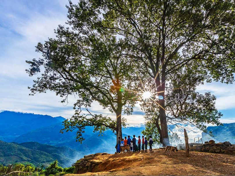
Compared to urban parks, Choan Then Park is not elaborate in its infrastructure but impresses with its simplicity and spaciousness. Amidst this space stand out two "a gừ" chestnut trees growing next to each other, with wide canopies that are green all year round. The image of the two chestnut trees standing side-by-side has been affectionately called by many tourists names like "tree of happiness" or "tree of love", becoming a familiar photo stop when visiting Y Ty.
Thanks to its convenient location, Choan Then Park is often included in itineraries combining Y Ty – Lao Than – Lung Po Flag Tower. After a trekking journey or border tour, stopping at Choan Then offers visitors a moment of quiet to feel the slow, close-knit pace of life in the highlands, where nature, culture, and people blend harmoniously.
5. Notes when visiting Lung Po Flag Tower
When visiting Lung Po Flag Tower, tourists should prepare neat, comfortable clothing for easy movement and climbing the 125 steps inside the tower. Due to its border location and relative altitude, the weather here is often windy and chilly, especially in the early morning and late afternoon, so a light jacket, windbreaker, or thermal shirt is essential.
On sunny days, visitors should bring a hat, sunglasses, and sunscreen to protect their health. Drinking water and some light snacks should also be prepared, especially for those combining a visit to Lung Po Flag Tower with nearby tourist attractions in a day. Cameras or phones should be fully charged, with a power bank, to conveniently capture moments of the national flag flying and the confluence of Lung Po stream with the Red River.
Visitors must strictly comply with the regulations at the attraction and follow the instructions of the border guards. (Source: Collected)
The most ideal time to visit is in the morning or early afternoon, when the weather is stable, visibility is good, and it is convenient to observe the panoramic view of the mountains and forests and the Red River flowing into Vietnam. On days with heavy rain or thick fog, visitors should reconsider their itinerary due to limited visibility and slippery mountain passes.
This is a particularly important border area, so visitors must strictly comply with the regulations at the attraction and follow the instructions of the border guards and management staff. Do not arbitrarily enter areas outside the permitted scope, especially near the border and boundary markers. When taking photos of local people, you should ask for permission beforehand, while respecting customs and traditions, maintaining general hygiene, and behaving civilly to contribute to protecting the image of the destination, **Lung Po Flag Tower**.
6. Suggested Itinerary: Sa Pa - Lung Po
6.1. One-Day Itinerary
Depart early from Sa Pa, passing through Lao Cai city – Bat Xat – A Mu Sung – **Lung Po**.
Time | Main Activity |
Early Morning | Depart from Sa Pa, travel through Lao Cai city – Bat Xat – A Mu Sung commune. |
Morning | Visit **Lung Po Flag Tower**, border marker number 92. Combine with admiring the confluence of Lung Po stream and the Red River, taking photos, and learning about its history and symbolic meaning. |
Noon | Lunch at Bat Xat district center or on the way back. |
Afternoon - Evening | Return to Sa Pa and freely explore the central area. |
6.2. 2-Day Combined Itinerary: Sa Pa – Fansipan – Lung Po Flag Tower
Day | Time | Main Activity |
Day 1 | Morning - Noon | Visit and experience entertainment at **Sun World Fansipan Legend**, and have lunch there. |
| Afternoon | Experience the modern cable car to the Fansipan peak, check-in at the "Roof of Indochina", and visit the cultural-spiritual complex. |
| Evening | Stroll through the central area and enjoy local cuisine such as Thang Co and salmon hotpot. |
Day 2 | Morning | Depart from Sa Pa to Bat Xat – A Mu Sung. |
| Noon | Visit **Lung Po Flag Tower**. |
| Early Afternoon | Admire the rivers and streams, learn about the meaning of sovereignty and history. |
| Afternoon | End of the trip and return. |
If you have more time, you can extend the itinerary to Y Ty to explore Lao Than, Choan Then Park, or the villages of the Ha Nhi and Mong people. Combining **Lung Po Flag Tower** with Sa Pa and Y Ty makes the Northwest journey more complete, offering both majestic scenery and rich historical depth and cultural identity.
**Lung Po Flag Tower** is a sacred symbol at the source of the Red River flowing into Vietnam, where the national flag shines brightly over the border river. The journey of climbing 125 steps amidst the mountain wind, standing under the 25m flag, facing border marker 92, is an unforgettable experience that awakens pride and love for the homeland. Come to feel and share beautiful moments, contributing to spreading the values of this sacred borderland!