1. General Introduction to Bach Moc Luong Tu
1.1. Geographical Location and Special Altitude of Bach Moc Luong Tu
Bach Moc Luong Tu is located in a rather special position, serving as the natural boundary between two northern mountainous provinces, belonging to the majestic Ky Quan San range. To the southwest, this peak borders Sin Suoi Ho commune, Phong Tho district, Lai Chau province; while to the northeast, it belongs to Sang Ma Sao, Bat Xat district, Lao Cai province.
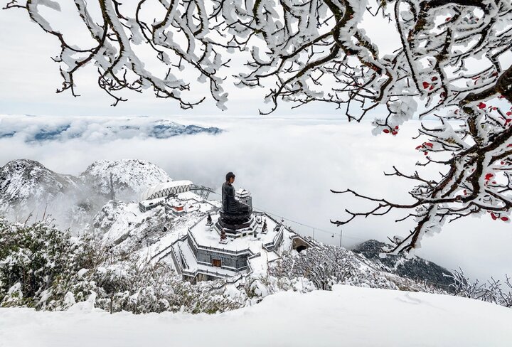
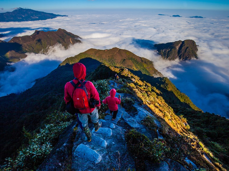
With an altitude of 3,046 m, Bach Moc Luong Tu is among the highest and most beautiful peaks in Vietnam, second only to a few famous peaks like Fansipan. This altitude not only challenges endurance but also offers conquerors unique moments of the Northwest border region - where the sky, clouds, and mountains blend to create an impressive landscape.
Its bordering location further contributes to the diversity of climate, vegetation, and local culture. During the trekking process, visitors can clearly feel the change from temperate climate at the foot of the mountain to subtropical as they ascend, while witnessing the unique intermingling of the ecosystems of the two regions.
Bach Moc Luong Tu is among the high and beautiful peaks in Vietnam. (Source: Collected)
Those who have conquered Bach Moc Luong Tu all agree that the path to the summit requires perseverance. The trail winds through dense green primeval forests, continues up steep rocky mountain slopes, then opens up to wide grasslands, creating a journey rich in scenery. This diversity makes the mountain an attractive choice for those who love challenges and want to explore the pristine beauty of the great forest.
1.2. Meaning of the name and history of exploration
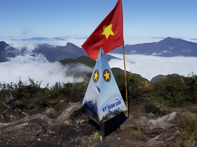
The name Bach Moc Luong Tu, along with Ky Quan San, are two names that preserve the imprint of local language and culture, passed down through generations by the H'Mong people on the border of Lao Cai and Lai Chau. These two names often appear together, with Bach Moc Luong Tu referring to the highest peak, while Ky Quan San is the name of the entire vast mountain range.
In 2016, VTV4 released a documentary film exploring “Conquering Ky Quan San”, marking a turning point that made this mountain more widely known, attracting a large number of young trekking enthusiasts nationwide. By early 2018, the Bat Xat authorities officially installed a new stainless steel marker bearing the name Ky Quan San, replacing the Bach Moc Luong Tu marker previously erected by trekkers.
From this marker, Bach Moc Luong Tu - with an altitude of 3,046 m - is recognized as the fourth highest peak in Vietnam, after Fansipan, Pu Ta Leng, and Pu Si Lung. Nevertheless, many tourists still refer to this trekking route by its old name. The strong development of mountain climbing and cloud hunting has made this mountain a new choice for adventure seekers.
Initially, the Bach Moc Luong Tu route was mainly explored by locals and experienced backpackers. As the trekking trend grew, travel companies began offering day and night tours, opening up opportunities for many adventure enthusiasts to experience this "cloud hunting paradise".
2. What makes Bach Moc Luong Tu a famous trekking destination
2.1. Unique ecosystem and "sea of clouds"
The ecosystem at Bach Moc Luong Tu is like a rich painting, changing diversely with each altitude. When starting the journey from the foot of the mountain, you will pass through lush cardamom fields and terraced fields winding around the mountainside, bearing the mark of highland life.
The primeval forests and cardamom forests at Bach Moc Luong Tu are home to many rare plant species. During certain months of the year, azaleas bloom on the mountain slopes, covering the space with vibrant colors amidst the deep green of the ancient forest.
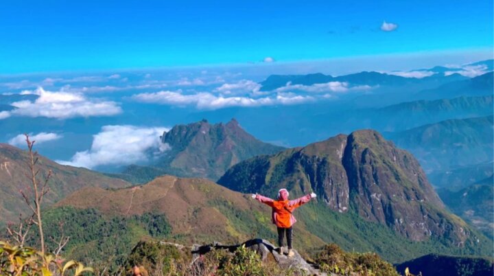
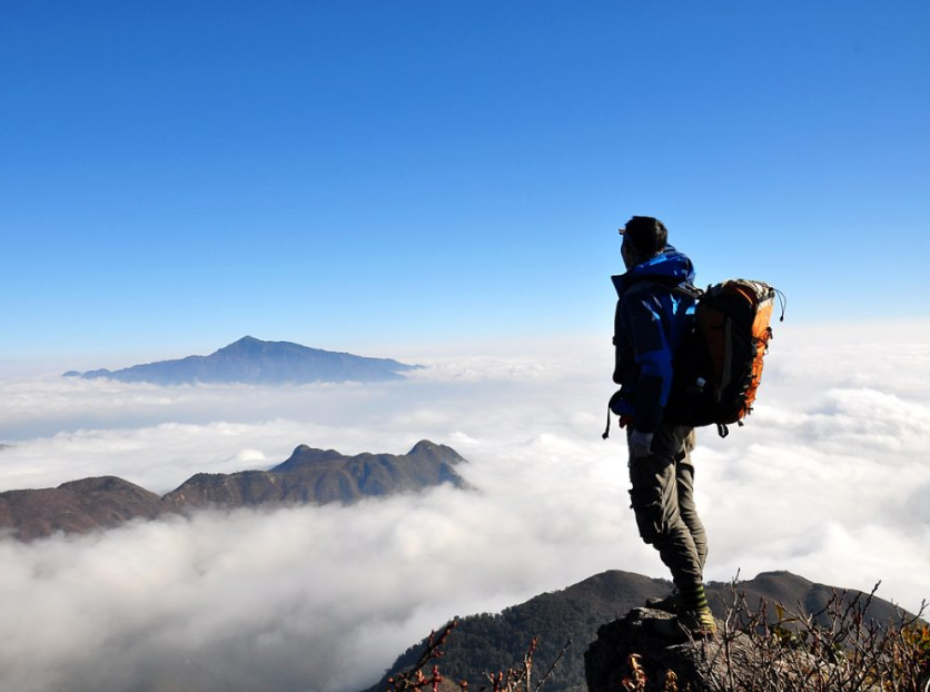
At an altitude of about 2,800 m, Muoi Mountain is famous as one of the most ideal spots for cloud hunting and watching the sunrise. Standing here, the view opens up to vast, undulating mountain ranges and the deep valleys below.
Bach Moc Luong Tu has become a famous trekking spot thanks to many natural advantages. (Source: Collected)
The unique feature of Bach Moc Luong Tu is the sea of clouds that appears almost year-round. Thanks to the characteristics of the Northwest highlands' climate and an altitude of over 2,000 m to 3,000 m, this place is often covered by thick clouds, creating a feeling of being lost in a world where white clouds spread beneath your feet.
2.2. Challenging trekking route, memorable experience
The Bach Moc Luong Tu trekking route is about 30 km long, usually arranged into a 3 or 4-day journey to ensure trekkers have enough time to adapt to the altitude, maintain physical strength, and observe the scenery.
Route 1: Foot of the mountain → Primary forest
Difficulty: Low
Terrain: Small dirt paths, trails through terraced fields, cardamom gardens
Ecosystem: Highland agriculture - streams, grasslands, cardamom gardens
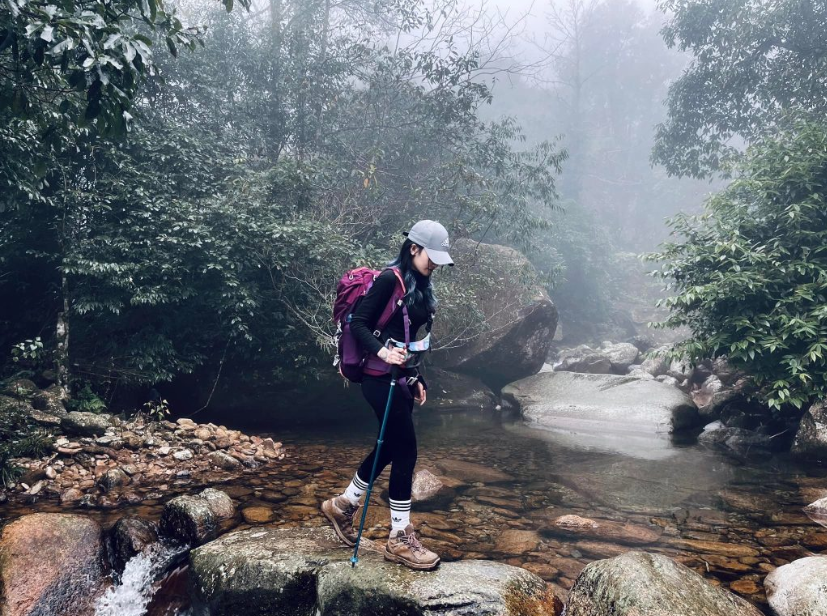
The first leg has relatively flat terrain, passing through areas cultivated by locals. This is the easiest section to adapt to, helping trekkers feel the rhythm of mountain agricultural life. After crossing streams and layers of terraced fields, the path begins to lead into the primary forest , where the tree canopy is denser and the air humidity increases noticeably.
Route 2: Primary forest → Overnight stop → Muoi Mountain
Difficulty: Medium - High
Terrain: Gradually increasing slope, tangled roots, small rocky cliffs
Requirements: Maintain stable breathing, good grip
The section from the overnight stop to Muoi Mountain is one of the most physically demanding parts. Trekkers must constantly grip roots, overcome low cliffs, and maintain a steady pace to avoid getting out of breath. It is on this leg that many people truly feel the challenging nature of Bach Moc Luong Tu.
Route 3: Muoi Mountain → Bach Moc Luong Tu Peak (3,046 m)
Difficulty: High
Terrain: Continuous steep slopes, narrow paths, slippery after rain
Requirements: Good trekking shoes, ability to navigate steep and rough terrain
From Muoi Mountain to the summit is the most difficult part of the entire journey. The slope increases sharply, with many sections requiring the use of both hands and body to grip rocks or tree trunks. During the rainy season, mud makes the path slippery, forcing trekkers to be cautious with every step. However, this is also the section where sea clouds often appear in the early morning – a worthy reward for those who conquer this final route.
Additionally, campsites and overnight stops along the route are conveniently located on flat ground in the forest or near Muoi Mountain. There, you have the opportunity to experience a night deep in the forest, gaze at the clear starry sky, enjoy the cool air, and feel the clouds drifting lazily just below.
2.3. A fairy-tale world on Muoi Mountain
During the journey to conquer Bach Moc Luong Tu , Muoi Mountain at an altitude of about 2,100 m is always a memorable stop for many. The name “Muoi Mountain” originates from the characteristic vegetation here, where salt-grass grows in clusters, creating a very unique hue amidst the mountainous forest landscape.
The name "Salt Mountain" originates from the characteristic vegetation here. (Source: Collected)
Salt Mountain evokes the feeling of stepping into a "fairytale world" amidst an ancient forest, where old trees intertwine to form a natural canopy, and hills and mountains follow each other with soft curves. Standing here, visitors can observe a rich ecosystem: primeval forest, wild grass, and low-lying vegetation.
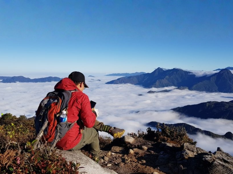
Sunrise at Salt Mountain is an experience many trekkers believe is hard to find elsewhere. As the sun slowly rises in the east, the first light casts a pale pink hue over the sea of clouds, making the entire space incredibly warm.
Many recount that when standing amidst the sea of clouds, they clearly feel the vastness of the mountains and forests and their own smallness, a moment both humbling and profound. Such experiences make Salt Mountain an important highlight of the route, where landscape, climate, and emotions blend into an unforgettable whole.
3. Notes when preparing to conquer Bach Moc Luong Tu
For a safe and complete journey, trekkers need to prepare adequately in terms of clothing, equipment, nutrition, medical supplies, and personal safety. The table below summarizes the important categories:
| Category | Suggested Material | Function |
| Trekking clothes | Breathable, moisture-wicking, quick-drying material; long-sleeved shirt - long pants | Reduces friction, prevents insect bites, keeps warm when altitude changes. |
| Thermal clothing | Thermal base layer, lightweight down jacket, windbreaker, woolen hat, neck warmer, gloves | Night temperatures can drop significantly; the body needs stable insulation. |
| Lightweight rain jacket | Compact, good waterproofing | Mountain weather changes rapidly, with sudden rain. |
| Thick trekking socks | At least 1-2 pairs | Help prevent blisters and keep feet warm. |
| Specialized trekking shoes | Good grip sole, waterproof | The trail has many steep, muddy sections, and streams → reduces slipping and ankle sprains. |
| Trekking poles | 1–2 poles depending on habit | Assists with balance, reduces pressure on knees when going uphill or downhill. |
| Trekking backpack | 30 - 40L, with waist and chest straps, waterproof | Good weight distribution, does not cause shoulder pain on long treks. |
For independent trekking groups, the tent - sleeping bag - sleeping pad set is essential. Tents should be lightweight, windproof, and waterproof, suitable for high mountain terrain. Finally, a sleeping pad helps insulate the body from the cold ground, minimizing heat loss and providing a more stable sleep after a day of intense activity.
Food and water are also categories that need careful consideration. Besides the main meals usually prepared in tours, you should bring dried food, chocolate, nuts, or energy bars for quick replenishment when your body lacks energy on steep sections.
Trekkers need to prepare adequately in terms of clothing and equipment. (Source: Collected)
Finally, the survival and mobility support gear includes a flashlight or headlamp (with spare batteries), a large-capacity power bank, sunscreen, insect repellent, a multi-tool, and a lighter.
These are small items but highly practical, especially for early morning or late evening treks, or for handling unexpected situations in the forest. A personal trash bag is also essential to protect the environment and demonstrate civilized trekking etiquette.
4. Bach Moc Luong Tu 3-Day, 2-Night Itinerary
4.1. Day 1: Sa Pa - Bach Moc Luong Tu (Ky Quan San)
The first day of the journey is about getting acquainted with the terrain, climate, and the characteristic trekking pace of the Northwest mountainous region. Starting from Sa Pa, the group will pass through important transit points before setting foot on the first mountain forest trail of Bach Moc Luong Tu.
This is a distance to help the body stabilize its pace, adapt to the altitude, and the change in terrain from residential areas to the primeval forest:
| Time | Activity | Detailed Description |
| 07:00 | Gather and travel from Sa Pa to Ky Quan San village | The group gathers, then takes a car through O Quy Ho pass; continuing for 8 km of pass and about 35 km to Muong Hum, then another 6 km to Ky Quan San village. Depending on the group size, motorcycles or 16-seater cars can be chosen. |
| 09:30 | Start trekking at the foot of the mountain | The main mountain climbing journey begins. The initial path follows cardamom fields, terraced fields, and gentle trails; suitable for getting used to the slope and breathing rhythm. |
| 11:30 | Lunch break in the forest | The group rests at a clear spot along the way. This is a time to refuel before entering a deeper forest section. |
| 16:30 | Arrive at the resting hut and rest | After crossing streams and entering the primeval forest, home to ancient trees hundreds of years old, the group arrives at the resting hut. The air begins to get chilly. |
| 18:30 | Dinner and overnight stay in the wooden hut | Dinner with local highland dishes and a warm campfire. The group stays overnight in the wooden hut, equipped with blankets, pillows, and insulated mats to prepare for the next trekking day. |
The first day concludes with the wild feeling of the Northwest mountains. From the trails through terraced fields to the densely packed ancient trees, every experience serves as a stepping stone for you to embark on the journey to conquer greater heights on the following day.
4.2. Day 2: Conquering Bach Moc Luong Tu Peak (3,046m altitude)
| Time | Activity | Detailed Description |
| 05:00 | Wake up early - move to Salt Mountain to welcome the sunrise | The group wakes up, has a light meal, and begins a short trek to Salt Mountain. The path goes through dense forest, where visitors can watch the sunrise, enjoy the sea of clouds, and take photos. |
| 07:00 | Warm-up - begin the ascent to the peak | The group ventures deeper into the steepest part of the entire journey. Many sections require clinging to tree roots, navigating mountain slopes, or crossing small rocks. This is a stretch that demands perseverance and steady breathing. |
| 12:00 | Reach the summit of Bach Moc Luong Tu (3,046 m) | Visitors reach the summit, rest, take check-in photos, and admire the panoramic view of the sea of clouds and mountains from the "rooftop" of Bach Moc Luong Tu. |
| 12:30 | Lunch on the way down | The group has lunch after leaving the summit, then returns to the resting hut to relax. |
| 16:30 | Return to the hut - rest and dinner | The group rests in the wooden hut, then has a cozy dinner and recovers energy for the final day of the journey. |
4.3. Day 3: End of the Journey
The last day on the Bach Moc Luong Tu journey begins with an early wake-up to watch the sunrise one last time from the campsite. Many take this time to reminisce, capture beautiful photos, and fully enjoy the natural beauty before departing.
| Time | Activity | Detailed Description |
| 05:30 | Watch sunrise or rest | Visitors can wake up early to watch the sunrise at Salt Mountain, or choose to sleep longer to recover energy before the descent. |
| 07:00 | Breakfast and pack personal belongings | The group has breakfast at the resting hut, prepares luggage, checks personal items, and cleans up trash before leaving the campsite. |
| 07:30 | Depart for the descent | The group begins the journey back to the starting point at Ky Quan San village. The descent is faster but still requires attention to steep sections, wet rocks, and slippery areas. |
| 12:00 | Arrive at the foot of the mountain - rest and have lunch | The group reaches the foot of the mountain, travels by motorbike taxi to rest, wash up, and have lunch. |
| 14:00 | Return to Sa Pa | A car picks up the group and takes them back to Sa Pa via the original route. |
The final day concludes the Bach Moc Luong Tu trekking trip with a gentle yet emotional journey. After returning to Sa Pa, visitors can treat themselves to relaxing moments such as a Dao red herbal bath, enjoying local highland delicacies, or simply sipping a hot cup of tea to fully recover.
The way down the mountain is faster, but visitors still need to pay attention to the steep sections. (Source: Compiled)
And if you still have lingering memories of the magnificent sea of clouds, you can absolutely spend time visiting Sun World Fansipan Legend, which recreates the majestic beauty of the Northwest from a different perspective: a cable car system that takes visitors across the valley, a serene spiritual architectural complex, and especially Fansipan peak - the "Roof of Indochina" that cannot be missed.
5. Practical Experience when Trekking Bach Moc Luong Tu
5.1. Safety, Health, and Environmental Preservation Notes
Physical training is an important preparation step before conquering Bach Moc Luong Tu. About 2-3 weeks before the trip, you should maintain exercises such as hiking, climbing stairs, or jogging to get used to continuous movement on steep terrain. Regular training helps the body adapt better to the actual trekking pace and reduces the risk of fatigue when climbing.
On the way, paying attention to safety is the top priority. Do not split from the group, especially when moving through deep forests or in foggy weather. Maintain a reasonable distance from other members and follow the instructions of experienced porters or guides to ensure the safety of the entire group.
Environmental protection is everyone's responsibility when visiting Bach Moc Luong Tu. Always collect your trash, do not break branches or pick flowers, use water sparingly, and limit noise to avoid disturbing forest animals. When passing through villages, dress modestly and ask for permission before taking photos of the locals to show respect for the local culture.
5.2. Experience in Cloud Hunting, Photography, and Check-in Spots
The ideal time for cloud hunting at Bach Moc Luong Tu is usually in late autumn and early winter, when the temperature difference between day and night is large, and clouds form densely. Sunrise at Nui Muoi or on the summit is when the sea of clouds is most brilliant and majestic, with sunlight filtering through the clouds to create an unforgettable impressive scene.

Sunrise at Nui Muoi or on the summit of Bach Moc Luong Tu is when the sea of clouds is most brilliant and majestic. (Source: Collected)
Nui Muoi, at an altitude of 2,800 m, is an ideal stop for panoramic photos with a dreamy sea of clouds and stretching mountain ranges. The summit of Bach Moc Luong Tu with its 3,046 m milestone is always an indispensable photo spot, capturing the proud moment of conquering a high mountain peak in Vietnam.
The trail through the forest, crossing cardamom fields and terraced rice paddies on the first day, creates a beautiful backdrop for storytelling photos. The moments of the group winding through the deep forest, crossing streams, and resting by the rice fields will make the journey more vivid and meaningful.
To make your photos stand out, you should choose brightly colored jackets such as red, orange, or yellow to create a highlight amidst the white clouds and green forests. Use the wide-angle mode on your phone to capture the overlapping sea of clouds. Shooting against the light during sunrise or sunset will bring unique and emotional artistic photos.
Bach Moc Luong Tu, with its mystical sea of clouds, diverse primeval forests, and challenging yet meaningful trails, is truly an unmissable experience for those who love adventure and aspire to conquer new limits. Prepare thoroughly and set off to personally feel the sacred beauty of the Northwest's "cloud roof"!