
1. Overview of the Sa Pa tourist map
Sa Pa - the land of mist, has long been known as a resort paradise of the Northwest region. Where winding terraced fields, peaceful villages, and majestic mountains blend into a captivating picture. Amidst countless attractions spread in every direction, the Sa Pa tourist map becomes an important tool to help tourists locate prominent destinations, build a reasonable itinerary, and optimize exploration time.
1.1. Sa Pa tourist map - visualizing all destinations
The detailed Sa Pa tourist map system is dedicated to tourists, helping to summarize and clearly display all destinations from the center such as the Stone Church, Sun Plaza to famous villages like Cat Cat, Lao Chai, Ta Van. Not only marking locations, the map also briefly describes the outstanding features and suggested experiences at each point, helping tourists easily visualize and select places that suit their interests.
A valuable advantage of the map is its ability to optimize routes. By understanding that places are close to each other, such as the Lao Chai - Ta Van village cluster, tourists can proactively group them into a single itinerary, significantly saving travel time and car rental costs. This is especially useful in Sa Pa - where the terrain is hilly and the roads into the villages can sometimes be difficult to navigate for newcomers.
Therefore, the Sa Pa tourist map becomes an indispensable companion, helping you to:
Arrange a scientific itinerary, suitable for your personal time.
Do not miss prominent destinations, including new areas or those deep in the valleys.
Easily find your way, minimizing the risk of getting lost when entering villages or mountain passes.
Experience Sa Pa more proactively and fully, by understanding the layout of attractions and how to connect them effectively.
2. Most detailed prominent areas on the Sa Pa tourist map
2.1. Sa Pa Center
The center of Sa Pa is where life is vibrant around the Square, marked by the Sa Pa tourist map as a suitable starting point for any tour. The entire central area is mostly convenient for walking and getting acquainted with the local terrain.
Sun Plaza
Sun Plaza Sa Pa is an iconic building among prominent tourist attractions in Sa Pa, consisting of 4 floors with a shopping center, restaurants, bars, ticket office for the Muong Hoa mountain train, and parking. The building stands out with its classic European architectural style. From the dome, clock tower to the details, everything is delicately designed, making the building a prominent highlight when tourists visit Sa Pa.
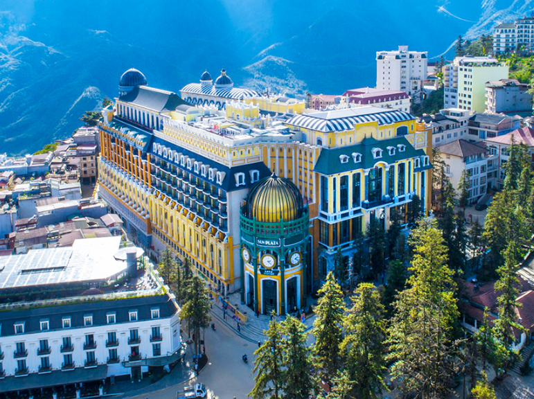
Sun Plaza Sa Pa is an iconic building among prominent tourist destinations in Sa Pa. (Source: Collected)
Inside Sun Plaza Sa Pa, visitors can explore a space with classic French architecture, featuring large columns, high domes, and a system of glass windows bringing in natural light. Floors 1 and 2 house the commercial center, restaurants, and cafes. Floor 3 is the food court and bar area, offering a relaxing experience. Notably, the building also has a ticket sales area for the Muong Hoa mountain climbing train, serving hundreds of visitors.
The architecture of Sun Plaza Sa Pa is strongly impressive with yellow and green tones reminiscent of the terraced fields and the Northwest mountains, combined with symmetrical patterns in classic European style. Large glass windows are arranged throughout the structure, making the building more dazzling when lit up at night. The clock tower at the entrance is also a prominent highlight, with a European architectural feel and has become a popular spot for many tourists to take photos when visiting Sa Pa.
Sa Pa Square
Sa Pa Square is located in the central area, opposite the Stone Church and just a few steps from Sun Plaza. Situated in a bustling area, it has become a familiar community space for locals and a convenient resting spot for tourists.
Cultural activities and art exchanges are frequently held in the square, especially on Friday and Saturday evenings. It is also a place where tourists can easily stroll, admire the mountain town, and connect with surrounding attractions. Before its current planning, the Sa Pa square area was a large open space used for various activities such as market fairs and community gatherings for local residents.
Visitors can visit Sa Pa Square at any time of the day. In the morning, the fresh air and lingering mist add to the poetic scenery, while the surrounding area becomes more lively after 7 AM. In the evening, the square becomes vibrant with traditional cultural performances, offering tourists an opportunity to experience the unique culture of Sa Pa in a dazzling, illuminated setting.
Sa Pa Stone Church
Sa Pa Stone Church was built in the late 19th century by the French. The structure features a strong Roman Gothic style with characteristic elements such as domes, a bell tower, and stained-glass windows. After more than a century, the church has retained its classic appearance and harmony with the mountain town's landscape. It is one of the oldest architectural works, closely associated with the formation and development of Sa Pa.
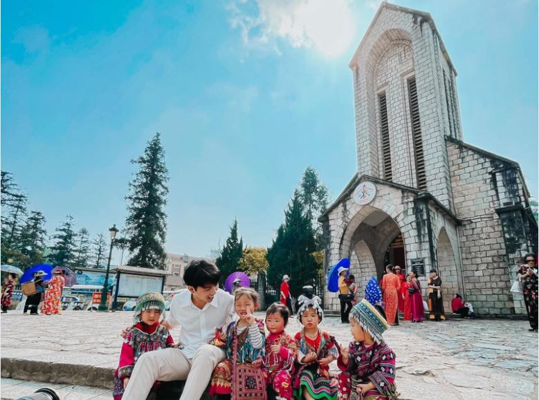
The church has become a popular tourist attraction for many visitors on their trip to Sa Pa. (Source: Collected)
More than just an architectural work, the Sa Pa Stone Church is also a familiar cultural meeting point for local people. The area in front of the church is where many community activities take place, from cultural exchanges to tourism events.
The Sa Pa Stone Church is a convenient stopover for tourists to begin their exploration of the Sa Pa central area. From here, you can stroll around the square, enjoy familiar snacks like grilled corn, grilled eggs, or shop for brocade items as souvenirs. Thanks to its prominent location and historical ambiance, the church has become a popular tourist attraction for many visitors on their trip to Sa Pa.
Sa Pa Night Market
Sa Pa Night Market is a familiar stop for tourists exploring Sa Pa in the evening. The area around the central square becomes bustling with stalls selling souvenirs, brocade items, and local specialties. Many performances showcasing the culture of the highlands are also organized, creating a very vibrant atmosphere.
At Sa Pa Night Market, tourists can enjoy many familiar dishes of the Northwest region such as grilled corn, grilled sweet potatoes, grilled eggs, or skewers made from buffalo meat and local pork. The aroma from the stalls lining the walkways creates a distinctly street-food atmosphere, attracting tourists to experience it.
Sa Pa Night Market is also a place for cultural exchange activities among local people. On Saturday evenings, this area becomes even more lively with the 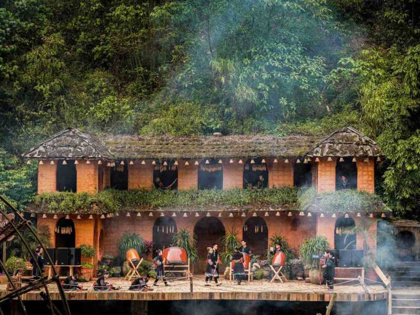
Cat Cat village offers visitors a vivid experience of local life. (Source: Collected)
Right from the entrance, visitors encounter a stone-paved path winding along the mountainside, with colorful brocade shops on both sides. One of the highlights of Cat Cat village is Cat Cat waterfall and the large water wheel system - a symbol closely associated with the agricultural production life of the highlanders.
Cat Cat village now has many homestays, cafes, and ethnic costume rental services, creating conditions for visitors to experience local life vividly. During the ripe rice season, the scenery on both sides of the mountainside turns golden, making the entire village a check-in spot that attracts a large number of tourists. This is a suitable choice for those who want to explore local culture in a friendly and easily accessible space.
Lao Chai - Ta Van Village
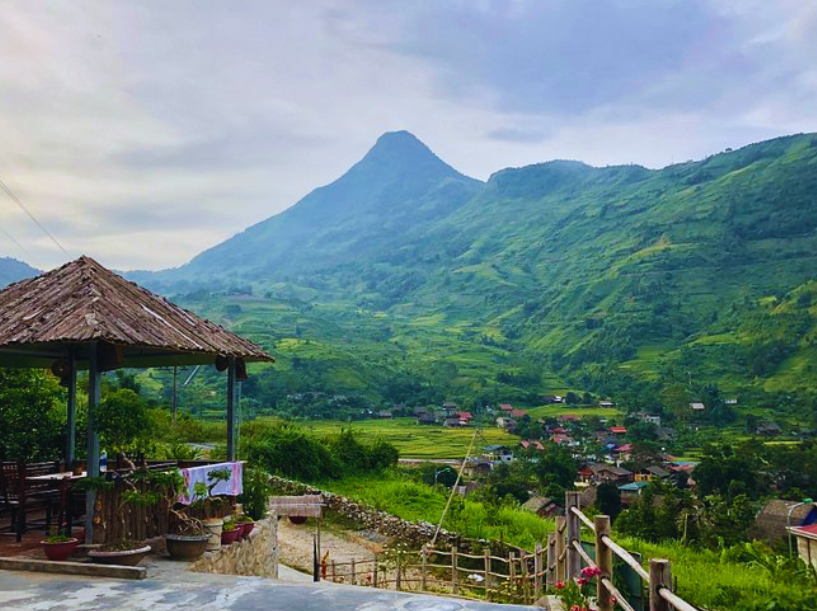
Lao Chai and Ta Van villages are located in Muong Hoa valley, about 8-10 km from Sa Pa center. Unlike the hustle and bustle of Cat Cat, these two villages offer a peaceful space in harmony with nature. This is also the area possessing the terraced rice fields system considered the most beautiful in Sa Pa, especially during the ripe rice season when the entire valley turns a vibrant yellow, creating a vast and impressive landscape.
The attraction of Lao Chai lies in its earthen-walled houses nestled amidst vast terraced fields, while Ta Van impresses with its rustic homestays located by the stream. Many tourists choose to stay in homestays to eat, rest, and live with local people. This is a way to experience local culture more authentically and deeply.
Ho Village
Ho Village has a rather special location compared to many other villages in Sa Pa, as it is located at a lower altitude and about 25 km from the center. This is home to the Tay community – an ethnic group with a rich cultural life, featuring wooden stilt houses, Xoe dance melodies, and cuisine with distinct highland characteristics. The peaceful and airy space makes it an interesting destination for tourists who want to experience local cultural colors.
Ban Ho village is suitable for those who want to immerse themselves in a simple way of life. (Source: Compilation)
The highlight of Ban Ho village is its well-maintained community tourism model. Visitors can stay in traditional stilt houses, enjoy familiar dishes such as grilled stream fish, wild vegetables, or corn wine prepared by the locals. In summer, the cool, clear stream becomes an ideal place to relax, bringing a sense of comfort amidst the lush green natural scenery.
Ban Ho village is suitable for those who want to immerse themselves in the simple way of life of the local people and enjoy the closeness to nature. From the village, you can also embark on many exciting trekking routes leading to further valleys and villages, exploring deeper the pristine beauty of the northwestern region of Sa Pa.
Ta Phin Village
Ta Phin village differs from villages like Cat Cat or Ta Van as it has largely preserved the cultural life of the Red Dao people. Located about 12 km northeast of Sa Pa center, Ta Phin is known as one of the typical villages for tourists who love traditional cultural experiences. It is also a convenient destination to learn about the life of the Dao community in Sa Pa.
Besides its cultural value, Ta Phin also possesses a natural landscape harmoniously blended with mountains and forests. Winding terraced fields, surrounding mountains, and some natural caves create a space that is both rustic and captivating.
The ancient Ta Phin monastery with its moss-covered French architecture is a prominent attraction, offering a different experience for visitors to the village. For those who wish to learn about traditional customs and rituals and enjoy tranquility, Ta Phin is a suitable choice for exploring the villages of Sa Pa.
2.3. Natural Scenic Spots in Sa Pa
The natural beauty of Sa Pa is clearly expressed through prominent scenic spots that you can easily locate on the Sa Pa tourist map . Each destination has its own unique imprint but blends into the overall majestic landscape of the northwestern mountains. Among them, Fansipan and the Sun World Fansipan Legend complex are always among the most chosen destinations by tourists when visiting Sa Pa.
SunWorld Fansipan and Fansipan Peak - The Roof of Indochina
The journey to conquer Fansipan - "the Roof of Indochina" - has become more convenient thanks to the modern cable car system. The cable car takes visitors across Muong Hoa Valley and the primeval forests of the Hoang Lien Son mountain range, opening up a panoramic view characteristic of Sa Pa. This is a way for tourists to feel the vastness and diversity of the ecosystem in the high mountain region.
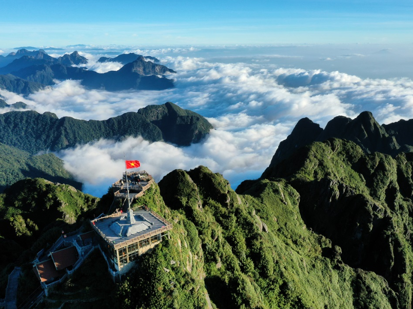
Tourists can observe the Hoang Lien Son mountain range stretching with layers of clouds moving below. (Source: Collected)
According to documents from the Vietnam Institute of Geology, the entire Fansipan mountain mass was actually formed from a giant granite block pushed up by tectonic activity over 250 million years ago. When viewed from above, the summit resembles a large hand reaching out from the forest canopy, creating one of the most characteristic landscapes of Sa Pa.
The moment of placing your hand on the 3,147m milestone is the perfect highlight of the Fansipan trip. From this position, tourists can observe the Hoang Lien Son mountain range stretching with layers of clouds moving below. To reach the summit, you can walk up over 600 stone steps or choose the Muong Hoa mountain climbing train. This is a journey combining nature experience and cultural exploration, offering a more comprehensive perspective of Sa Pa.
Ham Rong Ecological Tourist Area Sa Pa
Ham Rong Ecological Tourist Area is located in the center of Sa Pa and is often one of the first stops for many tourists. Thanks to its convenient location and carefully maintained landscape system, Ham Rong is likened to a "flower garden in the clouds" with thousands of flower species blooming year-round.
Upon reaching the summit, visitors will encounter San May (Cloud Yard) and Cong Troi 1 (Heaven's Gate 1) - two ideal spots to observe the entire panorama of Sa Pa and the Muong Hoa valley from above. On days with favorable weather, thick clouds often drift leisurely in this area, creating a very suitable atmosphere for "cloud hunting" activities.
With its diverse landscape and easily accessible paths, Ham Rong is a suitable choice for tourists who want to combine light exercise with sightseeing and nature experiences right in the center of Sa Pa.
Suoi Vang and Love Waterfall
Suoi Vang – Love Waterfall is located within Hoang Lien National Park, about 15 km from the center of Sa Pa and only 2 km from O Quy Ho Pass. The waterfall, nearly 100m high, is likened to a white silk ribbon cascading down amidst the ancient forest, merging with the clear Suoi Vang stream reflecting the shimmering sunlight.
At Suoi Vang - Love Waterfall, tourists can explore the primeval forest ecosystem with the Syzygium cumini tree - a Heritage Tree of Vietnam, cross precarious wooden bridges, admire the waterfall from the viewing pavilion, or immerse themselves in the cool water.

The waterfall, nearly 100m high, is likened to a white silk ribbon cascading down amidst the ancient forest. (Source: Collected)
On sunny days, rainbows often appear at the foot of the waterfall - a much-loved "photo hunting" scene. Additionally, this spot is the starting point for the Tram Ton trekking route, camping amidst green meadows, or combining with a visit to the peak of O Quy Ho Pass. For those who love nature and seek a fresh, tranquil feeling, Suoi Vang - Thac Tinh Yeu (Golden Stream - Love Waterfall) is one of the most worthwhile destinations to experience in Sa Pa.
Muong Hoa Valley
Muong Hoa Valley is nestled between two high mountain ranges of Sa Pa and is known as one of the most distinctive landscapes in the Northwest region. The highlight of this area is the terraced rice fields stretching along the mountainsides, creating an open and harmonious space. The Muong Hoa stream flowing through the center of the valley further enhances the poetic beauty of the entire panorama.

The Muong Hoa mountain climbing train line, the most modern in Vietnam, connects Sa Pa with the Fansipan cable car station. (Source: Collected)
A unique point in the valley is the Sa Pa Ancient Stone Field - a complex of stones engraved with mysterious drawings, believed to be thousands of years old. On the large and small stones are diverse patterns, from human shapes, stilt houses to abstract symbols. These engravings attract the interest of many researchers and offer visitors an interesting perspective on the long history of the Sa Pa land.
3. Experience using the most detailed Sa Pa tourist map
3.1. Tips for using Google Maps, offline maps
In today's technological era, combining traditional Sa Pa tourist maps with modern tools will make your journey more complete. Google Maps is a reliable tool for navigating major routes like National Highway 4D from Lao Cai to Sa Pa, or from the center to large villages. This application always updates the latest traffic information, helping you avoid construction sites or traffic jams during holidays.
However, in Sa Pa, many areas have weak signal, especially when going deeper into more remote villages. At this time, offline maps are very useful. Before coming to Sa Pa, you should download the offline map of Lao Cai province on Google Maps. With a not-too-large capacity, you can use it for many days without needing an internet connection.
3.2. Tips for combining asking locals and road signs
Combining the use of Sa Pa tourist maps with suggestions from local people will make your journey smoother and more authentic.
At the turnoffs to Cat Cat, Lao Chai, or Ta Van, the road system can be confusing if you only rely on the map. You can ask vendors or residents near the intersections; they often know the routes well and sometimes share beautiful photo spots that the map doesn't fully show.

Visitors can hire a tour guide for convenient access to the villages. (Source: Collected)
On the mountain passes, signs mainly provide distance information, rarely listing attractions along the way. Therefore, refreshment stalls and cafes at rest stops will be a useful reference for tourists. The owners are usually the ones who know the best times to admire the clouds or the spots with beautiful views for each attraction.
The villagers are also very friendly and willing to assist tourists. To avoid misunderstandings due to language barriers, you should prepare images or the names of the places you need to go. This method is particularly effective when you are looking for areas that are less marked on maps or not yet popular with many tourists.
4. Important notes when using Sa Pa tourist maps
4.1. Safety when traveling by map in Sa Pa
Sa Pa boasts majestic high mountain terrain, which also poses some safety requirements for tourists when consulting and traveling by Sa Pa tourist map .
On O Quy Ho pass and the road leading to the center, there are many steep sections and continuous sharp turns. Although the road surface has been improved, high humidity makes the surface slippery on rainy days. Tourists should choose motorcycles with disc brakes, deep treads, and maintain a speed below 30 km/h, especially when passing blind corners.
Between 6 PM and 7 AM the next morning, traveling by motorcycle on mountain passes is not recommended. Thick fog can reduce visibility to only a few meters, while winter temperatures sometimes drop below 5°C. Some road sections lack lighting, combined with steep slopes, increasing the risk of accidents.
During the rainy season, from June to August, the risk of landslides occurs in many places, especially on mountain passes and roads leading to villages deep in the valleys. The Lao Cai Provincial Meteorological Center regularly updates warnings via loudspeakers or local websites. Tourists should follow the weather forecast before departing and prepare alternative plans if prolonged heavy rain occurs.
4.2. Common mistakes when consulting maps
In reality, many tourists find it difficult to use detailed Sa Pa tourist maps due to the specific characteristics of the high mountainous region of the Northwest.
When using Sa Pa tourist maps, many tourists often encounter difficulties due to the terrain and climate characteristics of the Northwest high mountainous region. Some attractions located at altitudes above 2,000m, such as the Sky Gate or the area around Fansipan peak, frequently experience mobile signal loss or weakness.
When your phone loses signal, you can move to high, open areas like hillsides, access ramps to overpasses, or areas with less obstruction for your device to reconnect. Preparing offline maps or saving routes in advance also helps the journey proceed smoothly in conditions of weak signal.
Additionally, GPS location discrepancies of 20-50m often occur in valleys due to signal obstruction by mountains. If GPS indicates you have arrived but you don't see the location, check within a 100m radius. Many homestays and eateries in villages are located deep down small alleys and are only visible when walking in.
The inconsistency of the address system in villages is also a cause of difficulty. Instead of relying on house numbers, you should remember landmarks such as